
The Wahoo ELEMNT BOLT is a really good GPS cycling computer. This becomes clear when looking at most of the product reviews, and I can also second it from my personal experience.
But can it be used for mountain biking as well, especially for riding single tracks, including routing?
I couldn’t find any further information on that, especially since most reviews have been done by road cyclists.
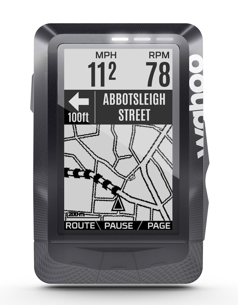
Note regarding the image: This doesn’t show an ELEMNT BOLT, but an ELEMNT – which has a bit larger display. The onscreen arrangement and resolution is similar.
The Basic Problem – Navigating the Woods
When riding a mountain bike in the woods, in contrast to riding on the street, navigation and orientation are a bit difficult. After all, there are not a lot of signs in the woods (apart from hiking path signage), and many paths are so small that they can be easily overlooked. This is especially the case when riding single trails. And often the speed is quite high, which means you don’t have time to orient yourself.
That’s why it’s quite helpful to have a device which constantly tells you where to go. The requirements for such a device are from my point of view:
- You need to be able to choose a route you want to go and store it on the device.
- The device must be able to constantly display a map with position and direction.
- The map needs to be very detailed, because you often ride tiny paths with an MTB.
- The device needs to react quickly to changes in position and direction.
- Turn-by-turn directions should be possible, they need to be clear and impossible to miss (e. g. when going at high speed with wind noise).
- Long battery life.
- It must be water and shock resistant. It must be able to survive a bike crash.
- Using it with gloves must be possible.
- Maps should be detailed enough for finding even small trails
Personally, I’ve tried the following devices in the past:
- Garmin Edge 205 (ca. 2006), GPS cycling computer
- Garmin Edge 800 (ca. 2011), GPS cycling computer
- Different smartphones (Samsung/Apple) and Apps (Open Street Maps, Komoot…)
With none of these devices did I have a lot of fun riding my MTB.
Riding Single Tracks with the Wahoo ELEMNT BOLT
To put it in a nutshell: the ELEMNT BOLT fulfills all requirements listed above. Now, the details:
1: Choosing a Route
The route can be stored on the BOLT very easily using the perfect smartphone integration. This can be done without any configuration effort, anytime, and (only) wirelessly, even on the go.
To be more precise, you use the Wahoo app’s integration with different cycling / outdoor services. Currently supported are for routes with turn directions: Komoot and RideWithGPS, plus the Wahoo ELEMNT app itself.
Example: You plan the route with Komoot, which then automatically appears in the Wahoo ELEMENT app and can be sent to the ELEMNT BOLT via bluetooth.
The actual route calculation doesn’t happen on the BOLT, but rather the turn directions need to be contained in the route data. This has the following advantages:
- no long-lasting route calculations on the device (a problem with some Garmin products)
- longer battery life because of fewer calculations
- no unwanted re-calculation of routes if you have gotten off the route (the BOLT simply can’t do that)
Side remark: The smartphone can stay at home. The BOLT works autonomously, once the correct route has been loaded.
2: Constant Map Display when Riding
The ELEMNT BOLT by default comes with a display page configuration “map” which also displays the speed. Any other further data fields can be easily added to it. With more than 2 data fields the maps display starts to become too small to be useful though. A key press leads to all other display pages (which are also freely configurable).
Some word regarding the map display quality: The ELEMNT BOLT has a black/white LCD display (resolution 320×240) with illumination, which is only needed in the dark or dusk. I was a bit skeptical first, because I’m a bit spoiled by all the very good smartphone displays. The BOLT’s display is totally sufficient for navigating using the map from my experience. The route and paths can easily be recognized and distinguished. A realistic impression of the map’s resolution can be seen in the image in the first paragraph of this page.
3: Detailed Maps
Wahoo uses OpenStreetMaps as it’s map base material. These OSM maps can be very detailed. In the Berlin area for example, every tiny path can be found in the map – in other regions this can of course be different.
Wahoo also updates the map material regularly, the updates can be very simply downloaded to the device.
Maps are provided for all of the world’s regions.
4: Rapid Reaction to Changes in Position and Direction
The ELEMNT BOLT supports GPS, GLONASS, and Galileo (and some more) and the speed and accuracy of positioning is absolutely sufficient for a fast-paced ride through the woods. I need to say that I wasn’t able to test this in very deep valleys (where sattelite connection may be worse).
If the map is set to be rotated with the riding direction (not pointing north), it turns just as you would expect it (no jerky turning of the map etc.)
5: Clear Turn-By-Turn Directions
If you ride a specific track, the map displays the surrounding paths. The path you need to ride is clearly indicated. If you get closer to a turning point, the distance to it is displayed. From a certain distance on, a popup is displayed and there is an acoustic signal, and also one from the integrated LEDs. Additionally, the LCD display’s illumination turns on for a short period.
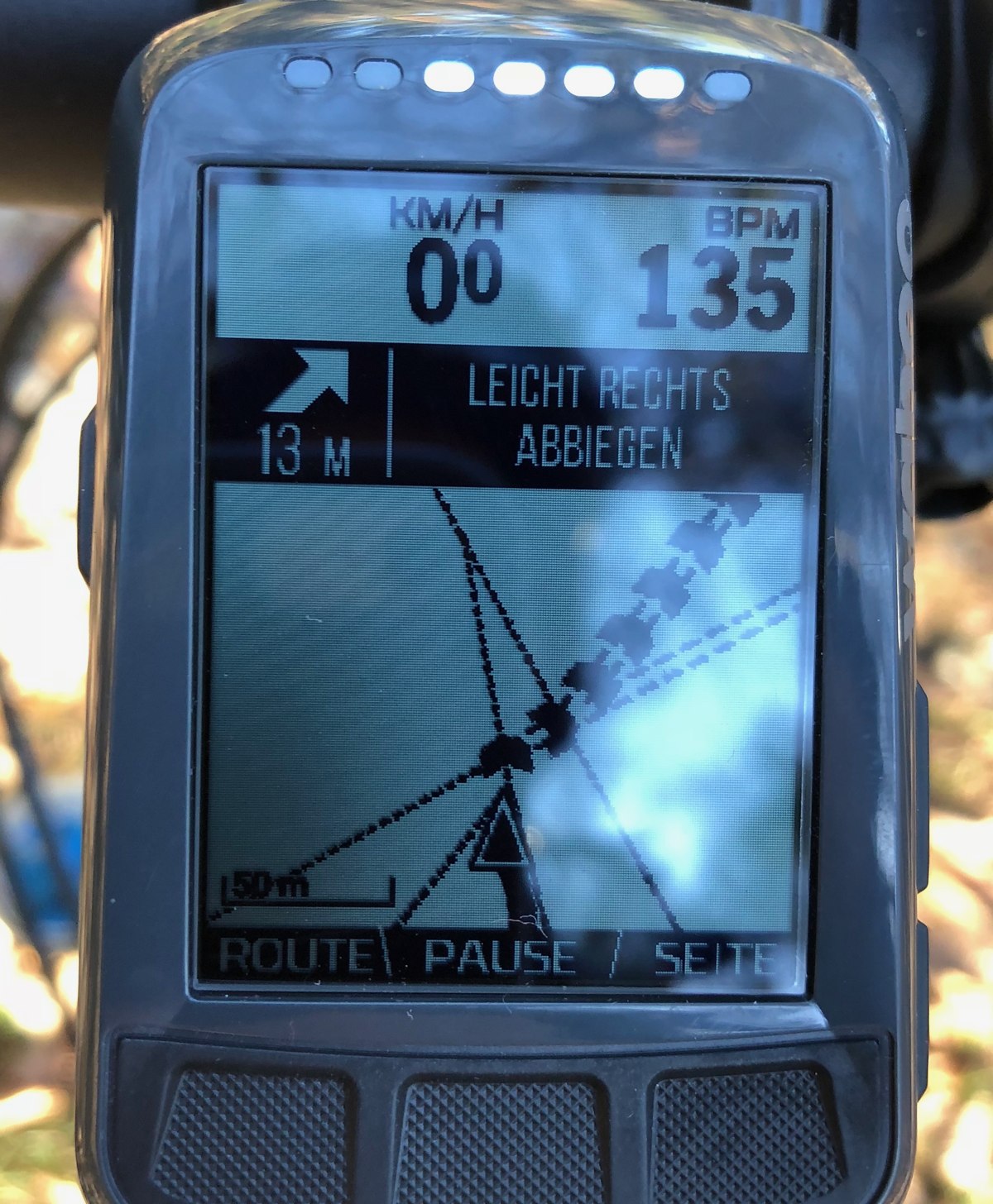
If you miss a turning point or get off the track, the BOLT also clearly indicates that with a different acoustic signal and a different LED color (red) for a couple of times. After about 10 seconds, this stops, so you can also keep on riding off the planned track without being bothered by constant alerts. This can be seen in the image on the right.
After getting off the track, if you get back on track at any place of the route, the ELEMNT BOLT reacts just as you would expect – it quickly recognizes that you’re back on track, and continues with guiding you on the track.
Also, you can start a route anywhere – you don’t have to pass the route’s starting point. As soon as the BOLT recognizes that you’re on the track, it turns on the routing.
Overall, the turn-by-turn directions and routing are very clear and can’t be overlooked.
6: Long Battery Life
According to different reviews and also from my own experience, the BOLT gets to at least 10 h on a single charge, with active routing, some illumination, LEDs and at temperatures around freezing point. When turning off some of the features, e. g. illumination or routing, you can probably get to the advertised 15 h, even at that low temperature (batteries last much longer when it is not that cold). So the BOLT seems to squash all competing devices with similar functionality.
7: Resistant to Water, Shocks, Crashes
As expected, the BOLT is small (so it’s protected by the stem and handlebar a bit) and light, and of course, sufficiently water resistant. I didn’t do any crash testing, but it sure looks quite robust. The mount also resists any strong shocks and vibrations which are common during mountain biking.
Those physical properties make it much better suited for outdoor sports activities than e. g. a smartphone mounted to your handlebar.
8: Usable with Gloves
The BOLT doesn’t have a touch screen, but physical buttons on both sides and at the bottom edge of the display. They can be used just fine even with winter gloves.
These buttons also offer good usability when the device is wet. With touchscreen devices, one often hears reports about input problems when they are wet (e. g. with some Garmin devices).
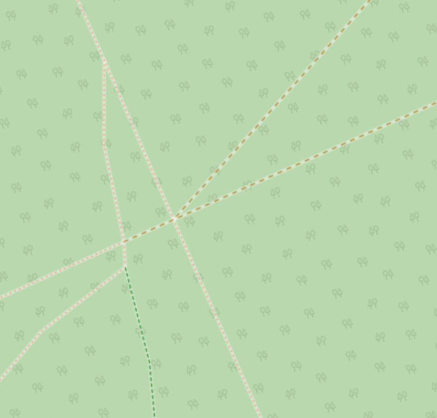
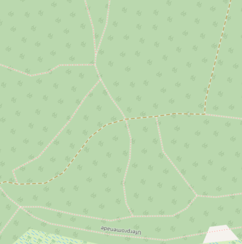
9: Maps level of detail
Wahoo uses uses Openstreetmaps as the basis for its maps. Not all details are visible, of course (Openstreetmaps contains data such as trees, powerlines etc., which are irrelevant for cycling) but the level of detail is totally fine when riding a bike (in and out of the city).
To compare some views, below are actual photos of an Element BOLT with map, and the same map view from Openstreetmaps.
Both examples show pretty well that all the necessary details regarding trails are visible, and also show that the different sizes of the trails can at least partially be seen.
Example 1:
Example 2:
TLDR; Summary
The Wahoo ELEMNT BOLT is well suited for mountain biking, especially riding single trails.
Hi, thanks for all the good info here. I have a similar list of requirements to what you’ve listed. I’d like to draw a route on a smartphone and upload the gpx to a device via BT. For route planning I’m using CartographPro on iOS. I can then export the gpx via “Open In…” menu to other apps. Any idea whether ELMNT app would support such an input? Does it appear in the Open In menu?
Matt,
I think this will work. I tried the following: I created a GPX file (on my laptop) and sent it to my iPhone via AirDrop. The iPhone automatically offered the Wahoo ELMNT app to open it.
I then stored it in the Files app, and Files also offered to open the file with the ELEMNT app.
Unfortunately I wasn’t able to test it with the CartographPro app because it’s not offered in the German app store.
Many thanks indeed! Sounds like Bolt is the way to go.
BTW, for some reason on the AppStore the app is called “Cartograph 2 Maps” but it shows app as CartographerPro once installed. It’s from an Austrian guy (https://www.cartograph.eu).
Thank you very much for the post. I have the same requirements and this was the only place where I could find good information whether Wahoo is well usable for mountain bike navigation.
Regarding 1., I’d add it’s also easy to use a route created on your own computer. Some part of Wahoo storage can be mounted using MTP and gpx routes can be simply put there under routes/ subdirectory. Turn-by-turn directions work with BRouter when using Locus style directions, although Wahoo converts fine directions to just one of the three “left”, “right”, “straight” (which is still better than with RideWithGPS where everything is apparently just “straight” and real instructions are just in comments). Comments can be added using gpx element, which I think can be very useful to not miss important waypoints.
Thank you SO MUCH!
I’ve been looking for a mtb review for the element bolt for ages!
Anyway, thanks again…
How is ELEMNT Bolt on MTB trails and ride recordings? On the road. It’s easy enough to maintain a descent amount of speed and GPS satellite coverage is not bad. On a MTB trail, it can be difficult to get a descent speed if the terrain is steep and satellite coverage can be spotty. Have you had any issues with Bolt and the ride uploaded to Strava?
Any experience with Garmin edge 130? What would you advise? Bolt or edge 130?
Some of my personal experience after an year with the bolt and 3+y with Garmin 520
1. I use ridewithgps to create routes from scratch. Skip this point if you already have the GPX/TCX
2. Import the route in http://www.bikehike.co.uk/mapview.php . Clear all the cues if any
3. Create my own cues. Add points for the peaks, the dangerous downhills, any water for the long routes. I also love to add points for 1/4, half and 3/4 for the long climbs.
4. Take note where the path splits. Then add cue turn points.
5. Unfortunately you can’t edit the text for the cue points within bikehike. There were other editors where you could, but they are offline now — any suggestion is welcome. That’s why I download the result .tcx file and manually edit it myself. It is text file with markups, it is easy to navigate and edit the part:
Right Turn
2018-09-26T10:32:05Z
42.618780
23.243940
0
Right
Leaving the fire road into singletrack
6. To confirm your track, you can load it in any site and check that it is loaded correctly. If happy, send the file to your phone and import it in Wahoo Companion App, then send it to the device.
The breadcrumbs are easy to follow, the Wahoo is much easier to zoom in/zoom out than Garmins and the default OSM maps are detailed enough. You can also add important metrics to the map screen and ride using this as your main screen. I tend to switch to the climbing/elevation screen when doing long climbs, when I know the route but I need to know how long till the top.
The main issue with the bolt is for the descends and fast flowy singletracks in the woods.
The Bolt loses GPS accuracy with fast movement, but the leeway off the track is very tight. As a result you get CONSTANT beeps from the bolt. Two notifications that you lost the track, followed by two notifications that you are back on track. And this repeats at least every minute! Even if you are following a track you recorded with the same unit!
In order not to get crazy but keep the useful notifications otherwise, I just draw the route way off the track. I get an instant notification I’m off, and then I can ride without it interfering, until the fast track is off where I draw again on track.
Thanks for all the information!
Regarding your last point: This (going off the track & constant beeps) has absolutely not been my experience with the BOLT. What I did notice, however, is that there are some areas where the map accuracy is too low, and the BOLT will ALWAYS think that I’m off track (and start beeping). On my most frequent ride this always happens at exactly the same positions, that’s why I attributed it to bad map accuracy. I think I can rule out bad GPS signal accuracy as a cause in my case for several reasons.
On my usual ca. 35 km / 20 mile ride (all trails / forrest, no roads) I maybe have a maximum of 4-5 spots where this happens.
I’ve been looking for a decent review of the Elemnt / Bolt and MTB requirements, and this is spot on! Nice succinct review, clear detail and very informative.
This has answered all my questions, thanks.
I have just purchased the wahoo element bolt. I have purchased the fill regions from komoot but when I try to plan a route and go to regions it asks me to purchase again. Do you help? Thank you.
Sorry, no idea. I use the komoot free account.
How can I have an idea about maps detail level? Is it the same of Open Street Maps?
I’m asking that because I had a bad experience with Lezyne Mega C: they said it had OSMaps… and indeed it had! But those maps were somehow simplified with a lot of trails missing. Even some tarmac driveroads…
I was forced to returned it back because it was useless for MTB.
Now I’m very interested in Wahoo bolt but I would not like to be in the same situation…
Thanks a lot,
Luca
In general, the map detail is pretty good. More details wouldn’t fit on the small screen/resolution.
I also added to the post a section (at the bottom) comparing the BOLT with the real OSM maps with some screenshots!